
I am a lecturer in the Department of Intelligent Vehicle Engineering, School of Mechanical Engineering, Chongqing Technology and Business University. I obtained my Ph.D. in 2024.12 from the State Key Laboratory of Information Engineering in Surveying, Mapping and Remote Sensing (LIESMARS), at Wuhan University, where I was supervised by Prof. BiSheng Yang and Prof. Zhen Dong. During my Ph.D., I collaborated closely with Dr. Jianping Li, a research fellow at Nanyang Technological University and Dr. Yuan Wang, a lecturer at Jiangxi Normal University. Prior to this, I received my M.S. degree in 2019 from the School of Geodesy and Geomatics, Wuhan University, where I was supervised by A. Prof. Li Zheng and A. Prof. Zheng Ji.
My research interests span Mobile Laser Scanning Point Clouds processing, Multi-modality Fusion and Localization, and Gaussian Splatting related 3D Reconstruction. I have published several papers in top-tier journals and conferences, including ISPRS Journal, Information Fusion, JAG, IEEE TGRS, and 测绘学报. You can explore my publications and citations on my Google Scholar profile 
🔥 News
- 2026.03: 🎉🎉🎉 One paper (AGI2P) is accepted by ISPRS J. (SCI1-TOP, IF: 12.7). Congratulations to Yandi.
- 2025.05: 🎉🎉🎉 One paper (OneStep-GSPE) is accepted by The 13th International Conference on Mobile Mapping Technology (MMT2025) and will be published on ISPRS Annals. (EI, Oral). Glad to meet you at Xiamen.
- 2025.04: 🎉🎉🎉 One paper (CVT Space Warping based Multi-scale Neural Implicit Surface Reconstruction for Outdoor Scenes) is accepted by Acta Geodaetica et Cartographica sinica (测绘学报). (EI, CSCD). Congratulations to Lu.
- 2025.02: 🎉🎉🎉 SaliencyI2PLoc is accepted by Information Fusion. (SCI1-TOP, IF: 14.8).
- 2024.12: 🎉🎉🎉 One paper (SaliencyI2PLoc) is available at Arxiv.
- 2024.11: 🎉🎉🎉 I have completed my PhD thesis defense.
- 2024.10: 🎉🎉🎉 One paper is accepted by JAG. (SCI1-TOP, IF: 7.6). Congratulations to Yuan.
- 2024.09: 🎉🎉🎉 One paper (CofiI2P) is accepted by IEEE RAL. (SCI2-TOP, IF: 4.6). Congratulations to Shuhao and Youqi.
- 2024.04: 🎉🎉🎉 One paper is accepted by TGRS. (SCI1-TOP, IF: 7.5). Congratulations to Xiaochen.
- 2024.04: 🎉🎉🎉 One paper is accepted by PHOTOGRAMMETRIC RECORD. (SCI3, IF: 2.4). Congratulations to Xin Zhao.
- 2023.09: 🎉🎉🎉 One paper (MuCoGraph) is accepted by ISPRS J. (SCI1-TOP, IF: 12.7).
- 2022.12: 🎉🎉🎉 Science and Technology Progress Award for Geographic Information, Second Class Prize, awarded by CAGIS.
- 2022.10: 🎉🎉🎉 One paper is accepted by JAG. (SCI1-TOP, IF: 7.6).
📝 Selected Publications

OneStep-GSPE: an Efficient 3D Gaussian Splatting Based Image Pose Estimation. Yuhao Li, Yipeng Lu, Jianping Li, Yuan Wang, Bisheng Yang, Zhen Dong. (EI, Oral). | Project Page.
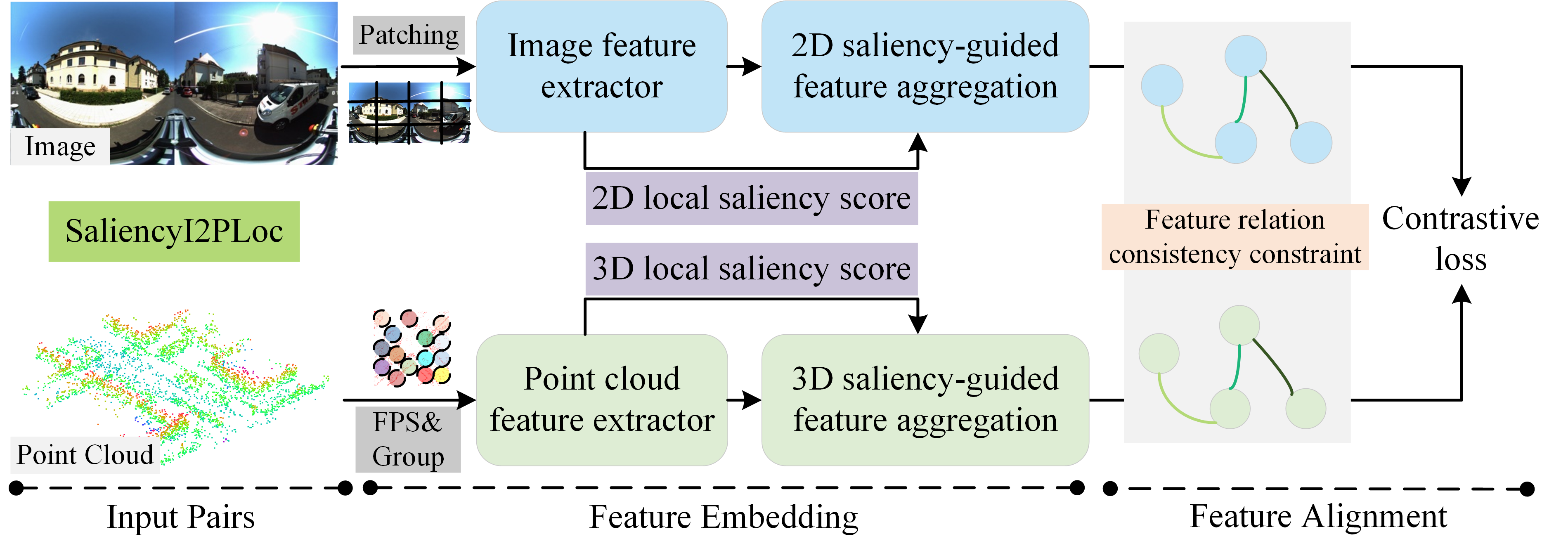
SaliencyI2PLoc: saliency-guided image-point cloud localization using contrastive learning. Yuhao Li, Jianping Li, Yuan Wang, Bisheng Yang, Zhen Dong. (SCI1-TOP, IF: 14.8). | Project Page | WeChat | Code | Arxiv | BiliBili.
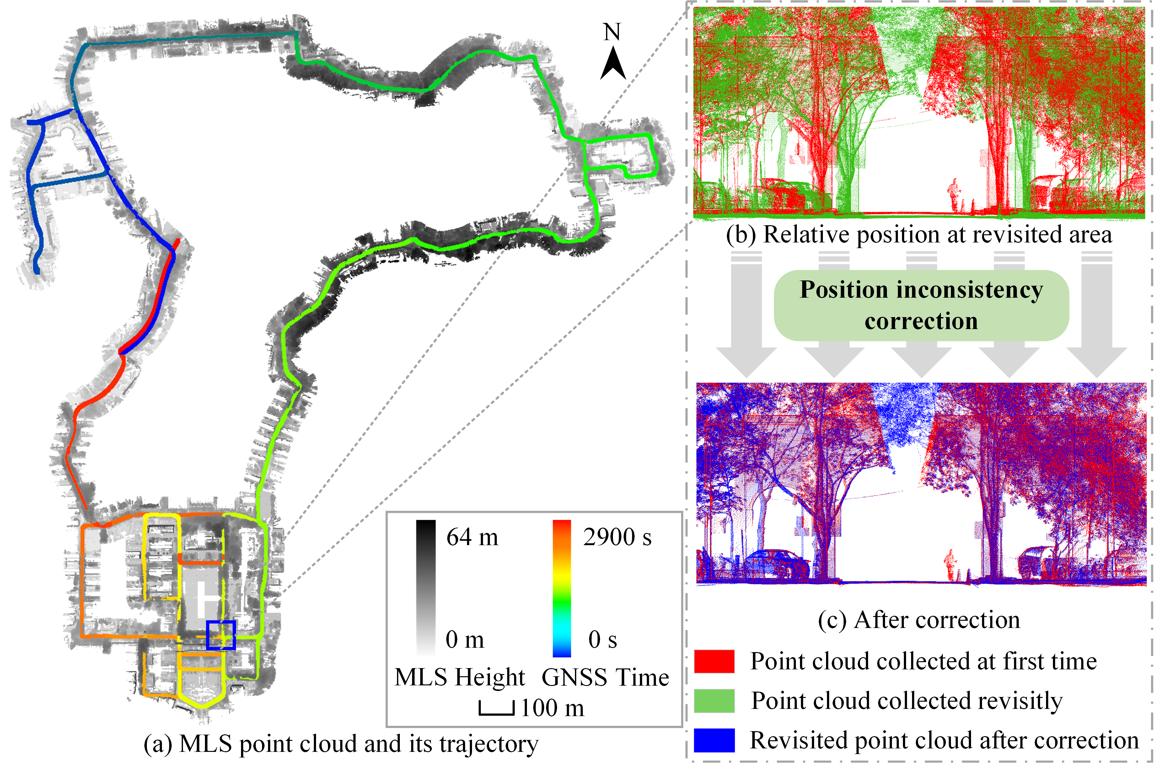
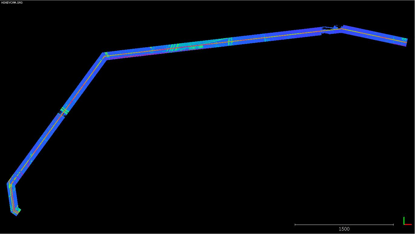
MuCoGraph: A Multi-scale Constraint Enhanced Pose Graph Framework for MLS Point Cloud Inconsistency Correction. Yuhao Li, Xianghong Zou, Tian Li, Sihan Sun, Yuan Wang, Fuxun Liang, Jianping Li, Bisheng Yang, Zhen Dong. (SCI1-TOP, IF:12.7). | Wechat | Youtube | BiliBili.
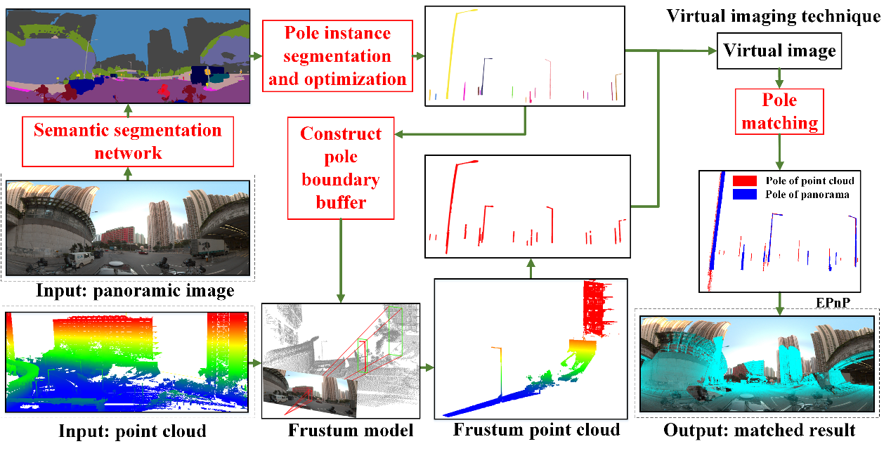
Automatic registration of point cloud and panoramic images in urban scenes based on pole matching.
Yuan Wang, Yuhao Li, Yiping Chen, Mingjun Peng, Haiting Li, Bisheng Yang, Chi Chen, Zhen Dong. (SCI1-TOP, IF:7.6).
-
ISPRS J 2026AGI2P: Benchmarking Aerial–Ground Image-to-Point Cloud Localization with a Large-Scale Dataset. Yandi Yang, Jianping Li, Youqi Liao, Yuhao Li, Ruizhe Niu, Yizhe Zhang, Zhen Dong, Bisheng Yang, Naser El-Sheimy. (SCI1-TOP, IF:12.7).Arxiv. 测绘学报 2025CVT Space Warping based Multi-scale Neural Implicit Surface Reconstruction for Outdoor Scenes. Yipeng Lu, Yuhao Li, Haiping Wang, Yuan Liu, Zhen Dong, Bisheng Yang. (EI, CSCD)JAG 2024Efficient Multi-modal High-precision Semantic Segmentation from MLS Point Cloud without 3D Annotation. Yuan Wang, Pei Sun, Wenbo Chu, Yuhao Li, Yiping Chen, Hui Lin, Zhen Dong, Bisheng Yang, Chao He. (SCI1-TOP, IF:7.6).RAL 2024CoFiI2P: Coarse-to-Fine Correspondences-Based Image-to-Point Cloud Registration. Shuhao Kang, Youqi Liao, Jianping Li, FuxunLiang, Yuhao Li, Xianghong Zou, Fangning Li, Xieyuanli Chen, Zhen Dong, Bisheng Yang. (SCI2-TOP, IF: 4.6). | Arxiv | ProjectPage | Code.TGRS 2024A novel method for registration of MLS and stereo reconstructed point clouds. Xiaochen Yang, Haiping Wang, Zhen Dong, Yuan Liu, Yuhao Li, Bisheng Yang. (SCI1-TOP, IF: 7.5). |Code.Phor 2024Coarse-to-fine adjustment for multi-platform point cloud fusion. Xin Zhao, Jianping Li, Yuhao Li, Bisheng Yang, Sihan Sun, Yongfeng Lin, Zhen Dong. (SCI3, IF:2.1). | WeChat.ISPRS J 20223D-CSTM: A 3D continuous spatio-temporal mapping method. Yangzi Cong, Chi Chen, Bisheng Yang, Jianping Li, Weitong Wu, Yuhao Li, Yandi Yang. (SCI1-TOP, IF:11.7).ISPRS Archives 2020A marker-free calibration method for mobile laser scanning point clouds correction. Bisheng Yang, Yuhao Li, Xianghong Zou, Zhen Dong. (EI).RS 2019Non-Rigid Vehicle-Borne LiDAR-Assisted Aerotriangulation. Li Zheng, Yuhao Li, Meng Sun, Zheng Ji, Manzhu Yu, Qingbo Shu. (SCI2, IF:4.2).
💻 Selected Projects
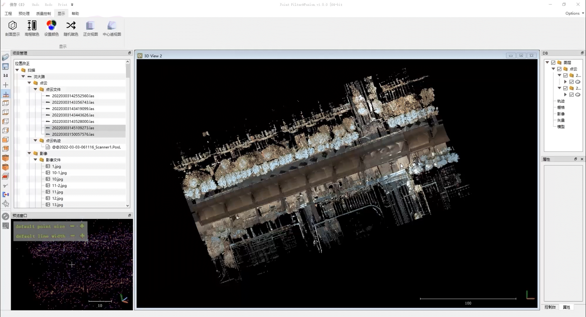
- Point cloud pre-processing tool development, 2022.12-2023.03, |
C++.
Point2Model development, 2021.07-2021.12. | C++ | Microstation| Commercial Software Page.
- Feature: MLS position inconsistency correction module, Cloud2Cloud distance check module.
Powerline inspection software development, 2021.03-2021.06, | C++ | Qt | Matlab.
- Feature: Automatic point cloud division of power corridor, Individual powerline coefficient estimation, Transmission line sag simulation, Point cloud and aerial image fusion, Risk detection and report print.
- MLS point cloud position correction UI development, 2019.07-2019.09. |
C++|Qt. - Open-Set Face Recognition, 2018.05-2018.08. |
C++|Python.
✍️ Services
Reviewer for Conferences: MMT2025
Review for Journals: ISPRS Journal, IEEE TASE, IEEE IoT-J, IEEE TAI, RS
🏫 Teachings
- Graduate student
Modern Sensors and Detection Technology (2025Fall, 2026Fall).
- Graduate student
ADAS Applications (2025Spring), STM32 Development (2026Fall), Technical Drawing (2026Fall).
🎖 Selected Honors and Awards
- 2022.12, China Association for Geographic Information Society (CAGIS), Science and Technology Progress Award for Geographic Information, Second Class Prize, Rank three.
- 2019.06, Outstanding Graduate Student, Wuhan University.
- 2018.08, The Fifth China Graduate Context on Smart-city Technology and Creative Design, Third Class Prize.
📖 Educations
- 2020.09 - 2024.12, Ph.D, LIESMARS, Wuhan University, Wuhan.
- 2019.07 - 2020.08, Research Assistent, LIESMARS, Wuhan University, Wuhan.
- 2017.09 - 2019.06, M.S., School of Geodesy and Geomatics, Wuhan University, Wuhan.
- 2013.09 - 2017.06, B.S., Tai Yuan University of Technology, Taiyuan.